Search
Close this search box.

MENU

    • Getting Here
      • Getting to the Daintree Coast

        Daintree Coast – Daintree River to Cape Tribulation.

        Catch the Daintree Ferry across the Daintree River and disembark on a journey through lush Daintree Rainforest and past spectacular coastline with the amazing Great Barrier Reef just offshore.

        Find out how to get here and other FAQs.

      • Welcome to the Daintree
    • Daintree Ferry
      • Daintree Ferry

        Your gateway to the Daintree Coast.

        The Daintree Ferry provides vehicle and passenger access across the Daintree River operating continuously between 5am to midnight daily.

        On this page you will find the latest ticket prices and all you need to know about catching the Daintree Ferry.

      • Daintree Ferry Crossing
    • Forest Creek
      • Forest Creek

        Forest Creek is the closest Daintree Coast location to the Daintree Ferry.

        The first turn off after disembarking the Ferry on the North side of the Daintree river, Forest Creek Road is a lovely drive through rainforest and rural landscapes.

      • Forest Creek
    • Kimberley
      • Kimberley

        At the end of Cape Kimberley Road is the stunning Cape Kimberley beach with Snapper Island just offshore.

        On a clear sky day you can see the Low Isles and Low Isles lighthouse in the distance.

      • Cape Kimberley
    • Cow Bay
      • Cow Bay

        North of Alexandra Range you will find Cow Bay.  Take a drive down to the end of Buchanan Creek Rd (6km) to arrive at picturesque Cow Bay Beach, where you can experience what a deserted beach feels like.

        Cow Bay is a great central location to base yourself to explore the Daintree Coast.

      • Cow Bay Daintree Coast
    • Diwan
      • Diwan

        The next Daintree Coast location on Cape Tribulation Road following North from Cow Bay is the enchanting area of Diwan.

        Here you will find some great places to stay, relax and unwind from campgrounds, luxury treehouses and rainforest cabins. Enjoy an ice cream at the Daintree Ice Cream Company, buy some locally grown Daintree Tea, fuel your car and stock up with goodies at Daintree Rainforest Village.

      • Diwan
    • Thornton Beach
      • Thornton Beach

        Between Diwan and Cape Tribulation, you will find the lovely and quaint Thornton Beach.

        Enjoy a leisurely stroll along the picturesque Thornton Beach, with charming Struck Island only 1 hectare in size just offshore.

        Here you will find a sheltered picnic table area to stop and revive, bungalow accommodation, a beachfront café and even crocodile wilderness cruises!

      • Thornton Beach
    • Cape Tribulation
      • Cape Tribulation

        Cape Tribulation, affectionately known as Cape Trib, is a popular destination with a rich history and spectacular scenery. You’ll find a lot to see and do at Cape Trib with plenty of accommodation options and great places to enjoy a meal.

        From rainforest and beach walks, treetop adventures, horse rides, and snorkeling trips at the Great Barrier Reef. There’s plenty to discover and explore.

      • Cape Tribulation
  • Stories
  • Living Here

Daintree Rainforest Articles

Daintree Coast – Be Amazed

Who named Mt Sorrow?

All our troubles with Mount Sorrow and Cape Tribulation and …. a few other locals.

Who named Mt Sorrow? Not Lt James Cook, but Captain Simpson of HMS Penguin (a Royal Navy Survey ship) in 1905.

Mount Sorrow photo by Lawrence Mason
Mount Sorrow - photo by Lawrence Mason

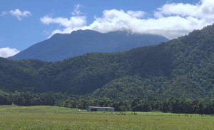
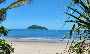
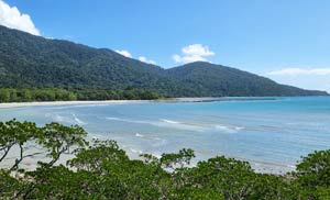
Mount Sorrow, Cape Tribulation

Cape Tribulation of course was famously named by Captain (then Lieutenant) James Cook during his famous First World Voyage, the 1770 mapping of the east coast of New Holland (now called Australia).
 
Cook’s original major task was to measure the transit of Venus. After completing this, he opened sealed orders instructing him to sail south and westwards to explore, map etc and find Terra Australia Incognita (Unknown southern land). Which didn’t and doesn’t exist, but that’s another story!
 
Cook subsequently named Cape Tribulation after coming to grief on the (Endeavour) Reef (“Here began all our troubles etc etc”). In a flurry of place-naming that happens when you’re one of the first to actually map a little-known continent (106 names in all), Cook also named Weary Bay (tired from pumping water from the his grief on the reef incident); Hope Islands (“We were always in hopes of being able to reach these Islands” after “fothering” the ship); and the Endeavour River (after the Ship).
 
There’s certainly no doubt about the naming of Cape Tribulation. It’s very well documented!
 
The naming of Mount Sorrow, (with its head draped in sorrow like Michelangelo’s Pieta), at the back of Cape Tribulation is more mired in controversy.
 
Some local wags credited Cook with climbing up the Mountain to seek a safe passage through the reef. He didn’t, as Cook’s logs clearly show that the ship was off Cape Tribulation at 3pm on the afternoon of 10 June, and continuing north/north east until smashing into the Endeavour Reef at 11pm that night. Cook had no time and no reason to wander up the mountain. At that time, Cook didn’t know enough about the local reef system to think he might be in trouble. The “troubles” started after Cape Tribulation.
 
And so did Cook’s hill-climbing. During ship’s repairs on the banks of the Endeavour River, Cook climbed up two hills (Grassy Hill, Mount Jensen), and three more after exiting the River (Cape Bedford, Cape Flattery and Lizard Island) where he eventually found a gap in the ribbon reef system.
 
So, back to Mount Sorrow. An even more fanciful story had Cook sending five men up Mount Sorrow. In one version, these men were allegedly attacked and killed by the local Kuku Yalanji people. Imaginative but again totally incorrect!
 
This version seems to be mixing the Cook saga with an earlier 1606 event on Cape York. Several crew members of the Dutch ship “Duyfken” were actually killed by the Wik people in retaliation for some severe misdeeds near Weipa at a place called Cape Keeweer (Cape Turnaround). The story has credibility as it is part of the Wik oral tradition, as well as being recorded in Dutch maritime history.
 
But still no Mt Sorrow.
 
After Cook, the next marine surveyor to head up this way was Matthew Flinders whose charts encompassed Cook’s earlier material as well his own. His 1802 visit account (published only in 1814) mentioned Cape Tribulation along with the earlier place names.
 
But again, no mention of Mt Sorrow.
 
In 1815, Lt Jeffreys of HMS “Kangaroo” named Snapper Island, but again no Mt Sorrow. Snapper Island was not named by George Dalrymple in 1873 as has been sometimes claimed – the earlier naming clearly takes precedence.
 
In 1819, Lt Phillip King on the “Mermaid” was the next major east coast surveyor. Again, Mt Sorrow was not mentioned, nor included on his charts, although he did include King’s very recently named Snapper Island. He also named the Blomfield (now Bloomfield) River after an Army Lieutenant friend recently appointed to New South Wales.
 
Lt King, son of Governor King, later became the first Royal Navy Admiral to be born in Australia. He also commanded the “Beagle” at one stage, although when Charles Darwin was on his epic voyage of enlightenment to Galapagos, Australia and other places.
 
Next contender for the sorrowful saga was the famous Capt Owen Stanley with his surveyor Lt Yule on their several ships, including the “Rattlesnake”, “Emu” and “Bramble”. The three ships undertook a series of mapping voyages between Sydney and New Guinea. On 19 July 1948, they named the tall peak behind Cape Tribulation as Mt Pieter Botte, because of its similarity to mountain in Mauritius, and named after the first Dutch East Indies Governor in Batavia, Indonesia. But still no Mount Sorrow.
 
Two obscure but notable points about the Rattlesnake. The first is that we don’t have rattlesnakes in Australia. The second is more remarkable. Capt Owen Stanley reports in his logs that the Rattlesnake became so cockroach-infected that he had to sink the ship temporarily to drown or evict the cockroaches, then refloated the ship afterwards. What a response! The ’roaches must have been really bad.
 
Back to the naming of Mount Sorrow, the difficult one! Some time ago, I put out a cry for help through the magic of the internet. A few weeks ago, maritime mapping expert Bill Kitson from Brisbane answered the call!
 
Mr Kitson believes that Mt Sorrow was first named from a chart done by Capt C H Simpson of the HMS Penguin 1905 (a Royal Navy Hydrographic ship commissioned on Australian survey duties). Of several captains during the multi-year survey, Simpson was the hydrographic surveyor (RN) doing the survey of the Cape Trib section.
 
The relevant plan (Cape Tribulation to Snapper island) has been transferred to the National Archives in London. So too is the Ship’s Log which might give a clue to why Simpson decided on the name “Mount Sorrow”. Both need further checking, but it costs a fair swag of money to do a search from Australia.
 
Mount Sorrow made its first newspaper appearance on 27 July 1916, in a sort of Travel Writer Blog in the The Australian Worker, pointing the mountain out to tourists in passing. So, the area was already starting to see its first tourists over 100 years ago.
 
So, the riddle of the naming of Mount Sorrow is almost solved. But not quite.
 
We now need a London-based volunteer to check out the National Archives. I can supply all the correct details, kindly supplied by Bill Kitson, to make the job simpler.
 
Can anyone answer the call again, please?
Picture of Mike D’Arcy

Mike D’Arcy

D’Arcy of Daintree
Mike spent many years as an interpretive Wet Tropics Tour Guide running his own business D’Arcy of Daintree 4WD tours. Now retired. Mike has a wealth of knowledge on the Daintree Coast region and continues to share this via his audio tours and blog posts on the Daintree Coast website.

Follow @ Daintree Coast

Members Login

Not yet a member? Join the Daintree Coast website to add local directory listings and post job vacancies & events.